A City Built on a Dream
The Wilderness Decree
Back in 1816 when Indiana achieved statehood, its original capital was Corydon along the southern border. Realizing that the future lay in the north, the General Assembly appointed a commission in 1820 to find a geographically central location. They decided upon a dense, swampy forest at the confluence of Fall Creek and the White River, mistakenly believing that the river would become a booming highway for commercial steamboating. By 1821, the legislature named this dream of a metropolis Indianapolis.
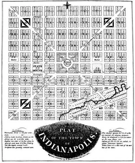
Ralston's 1821 plan for the City of Indianapolis - Alexander Ralston (1771-1827), Wikimedia Commons
The “Mile Square” by Alexander Ralston
Those men were ambitious. They hired surveyor Alexander Ralston to design a grand capital for them. Having previously assisted Pierre Charles L’Enfant in mapping out Washington D.C., Ralston brought a distinct, classical vision to the frontier. He designed a perfect one-square-mile grid that superimposed a wheel-and-spoke layout over a traditional gridiron.
The Anatomy of the Plan
The Centerpiece: A grand circular commons - originally the Governor's Circle (now Monument Circle) - was placed at the dead center of the plan.
The Cardinal Axes: Meridian Street (running north-south) and Washington Street (running east-west) divided the square.
The Diagonals: Four wide avenues (Massachusetts, Virginia, Indiana, and Kentucky) radiated outward from the center to maximize visibility and traffic flow.
The Crossroads of America
Although the White River turned out to be unnavigable and early residents battled isolation and mud, Ralston’s deliberate layout saved the city. The massive 120-foot width of Washington Street seamlessly accommodated the federal National Road, and the wide-open, flat grid proved perfect for the next technological revolution: railways.
In 1853, the city opened the nation’s first Union Station, solidifying its destiny not as a river port, but as the enduring “Crossroads of America.”
Iron and Interurbans - 1853 to 1920
After the opening of the world’s first Union Station, Indianapolis underwent a massive boom. During the Civil War, the city’s centralized rail network made it a vital logistics hub for the Union Army, moving hundreds of thousands of troops and tons of supplies through the Mile Square.
At the turn of the 20th century, a new rail phenomenon began to take over: the Interurban. These electric streetcars connected regional towns and villages directly to metropolitan centers. Indianapolis built the Indianapolis Traction Terminal in 1904 - the single largest interurban station in the entire world.
At its peak, the Traction Terminal saw more than 500 cars a day, shuttling over 7 million passengers a year from Indy and surrounding Indiana communities like Muncie, Fort Wayne, Lafayette, and even Bluffton. The city was a congested web of overhead electrical wires and steel tracks embedded directly into the cobblestone and brick streets.
Timeline of the Rail Empire and its Decline
The First Union Station Connects Indy
1853
The opening of the centralized depot solves the chaos of competing lines and establishes Indianapolis as the central transit node of the Midwest.The Romanesque Revival Rebuild
1888
To manage the exploding passenger traffic, the famous pink granite and red brick Union Station with its iconic clock tower replaces the modest 1853 structure.World’s Largest Traction Terminal Opens
1904
The electric Interurban network peaks, turning downtown Indianapolis into a central regional hub where over 38 separate interurban lines eventually converge.The Peak Year of Rail Transit
1920
Mass transit ridership hits its historical high. Paradoxically, this is also the era where Indiana emerges as a pioneer in automotive manufacturing (Marmon, Stutz, Duesenberg).The Great Depression and Bankruptcy
1930s
Economic collapse devastates the heavily leveraged private interurban lines. Lines are consolidated into the Indiana Railroad, but ridership plummets as state-funded paved highways expand.The Last Interurban and Post-War Cannibalization
1941-1953
The final interurban car rolls out of the Traction Terminal in September 1941. Following WWII, streetcar lines are systematically paved over or replaced by buses, culminating in the total removal of streetcars by 1953.
Why the Failure?
The collapse of the rail system in Indianapolis wasn’t an accident of history; it was a structural pivot driven by three main factors:
The Financial Trap of Fixed Infrastructure
The interurbans and streetcars were entirely privately owned utilities that paid heavily to maintain their own tracks, overhead wires, and power plants. When the state began utilizing public tax dollars to build and pave massive public highway networks, it effectively subsidized the rail lines’ direct competitor: the automobile.The Rise of the “Crossroads” Auto Industry
Hoosiers weren’t just consumers of cars. Indiana was the capital of making them. Early on, cities across the state were manufacturing elite automobiles. The political and economic momentum shifted entirely toward rubber-tired vehicles. Buses were marketed as modern, flexible, and “unshackled” from tracks, convincing city planners to pull up the rails.The Decentralization of Alexander Ralston’s Grid
Ralston designed the Mile Square to draw everyone inward toward a singular, dense core. The automobile allowed people to move outward, sparking the rapid development of the early suburbs. The population eventually spread far beyond the reach of existing rail lines, fixed streetcars couldn’t efficiently serve the sprawling city layout.
By the mid-1950s, the tracks that had driven the city’s rise were buried under layers of fresh asphalt, setting the stage for the era of the interstate system.
Interstate Highways Take Over
The private rails having collapsed, the state transformed Alexander Ralston’s deliberate urban grid into a driver’s nightmare or paradise depending on who you ask. Federal Money flooded in after the Federal-Aid Highway Act of 1956, and Indianapolis leaned into its identity as the “Crossroads of America.”
Instead of routing the interstate highways around the city center - As President Dwight D. Eisenhower had envisioned - planners ran them directly through the city center. The resulting 4.5-mile downtown highway loop, where Interstates 65 and 70 converge, entirely rewrote the city’s geography.
The Geometry of the Inner Loop
Construction of the I-65/I-70 Inner Loop during the 1960s and early 1970s was inspiration, and a monumental engineering feat, which came with immense structural and social costs.
To wedge multi-lane interstate highways into a city grid designed in 1821, something had to give. Planners utilized eminent domain to clear massive swaths of land. Statewide data and archival research show the staggering scale of this alteration:
Displacement: Approximately 8,000 buildings were demolished and over 17,000 residents were displaced across Marion County to clear the path for the concrete corridors.
The Neighborhood Divide: The highway cut like a pair of concrete shears through vibrant, dense urban neighborhoods. On the northwest side, it severed historically Black communities like Ransom Place and the areas around Indiana Avenue. On the near east and south sides, it sliced through working-class communities in Fountain Square, Fletcher Place, and Martindale-Brightwood.
The Elevation Controversy: Local advocacy groups and neighborhood leaders pushed heavily for the inner loop to be built below-grade (depressed into the ground) to minimize noise and visual walls. However, due to engineering challenges with downtown's high water table, existing sewer lines, and the path of Pogue's Run culvert, the state opted for an above-grade elevated system. The resulting massive earthen embankments and concrete viaducts created permanent physical barriers between downtown and its surrounding neighborhoods.
The Modern Re-Imagining
Shortly before I woke back up, around the 2020s, the original 50-year-old interstate infrastructure had reached the end of its functional lifespan. Structural deterioration and dangerous “weaving” patterns - where drivers frantically cross multiple lanes to navigate the tight splits - forced a major rethinking of how these concrete corridors can serve a modern midwestern city.
The North Split Reconstruction
Interchange of I-65/I-70 on the northeast corner of downtown
Completed in the early 2020s, this massive $350 million project replaced 44 aging bridges. Crucially, it stayed within the existing footprint to avoid displacing homes, widened pedestrian underpasses with lighting, and added a 3-million-square-foot urban forest landscape to soften the highway's visual impact.
The Rethink Coalition Vision
The “South Split” near Fletcher Place and Fountain Square
An active community-driven movement aiming to leverage the fact that the south split is already recessed. They propose shrinking the highway's physical footprint, capping the sunken lanes with structural lids, and building public parks and new housing directly on top of the interstate to stitch divided neighborhoods back together.
The Infrastructure Paradox: Alexander Ralston designed the Mile Square to draw the region inward toward a shared, centralized civic circle. The mid-century interstate system flipped that logic - it was engineered to help people bypass the city center entirely or escape out to rapidly growing suburbs.
Today, Indianapolis has come full circle. The conversation is no longer about how quickly cars can cut through the city, but how to heal the physical scars left by the highway era, blending the convenience of the “Crossroads” with the walkable, connected dream on which the city was originally founded. As we move forward, we find ways to perfect transit, and perfect the dream of a city - that was designed before a single brick was laid.
References
1. Alexander Ralston and the "Mile Square" Plan
Source: Encyclopedia of Indianapolis, "Alexander Ralston." Indiana Historical Society / Indianapolis Public Library.
Verification Note: Details Christopher Harrison appointing Ralston and Elias Pym Fordham to survey the 4-square-mile tract in 1821, modeling the grid and diagonal spokes after Pierre Charles L’Enfant’s Washington, D.C. blueprint.
2. The Interstate Inner Loop Displacement Data
Source: Indianapolis Monthly, "Fruits of the Loop: An Unsung Milestone in Indy's Downtown Development" by RetroIndy / Urban Design Archives.
Verification Note: Verifies the physical and social toll of constructing the elevated I-65/I-70 Inner Loop through the city core, confirming the displacement of 17,000 residents (including 6,000 from Fountain Square alone) and the destruction of roughly 8,000 buildings.
URL: https://www.indianapolismonthly.com/arts-and-culture/circle-city/i-65-i-70-inner-loop-anniversary/
3. The Origin of "Crossroads of America"
Source: The Historical Marker Database (HMDB), "Crossroads of America Historical Marker (Marker Number 84.1998.1)." Indiana Historical Bureau / Vigo County Historical Society.
Verification Note: Documents that the moniker was originally designated in 1926 for the intersection of U.S. Highway 40 (the National Road) and U.S. Highway 41 in downtown Terre Haute, Indiana, before the state legislature adopted it as a statewide motto.
4. General State Motto History
Source: Wikipedia, "Crossroads of America."
Verification Note: Confirms that the Indiana General Assembly passed a formal resolution on March 2, 1937, establishing the phrase as the official state motto, and notes that Indianapolis officially adopted it as a city slogan later in 1988.