The Day the Sky Wiped It All Away
April 11, 1965 began as a welcome gift. An unseasonably warm, beautiful spring Sunday. A day where Hoosiers flocked outside for backyard barbecues, washed their cars, and walked to morning church services. No one had any idea they were in the crosshairs of a meteorological nightmare.
By late that afternoon, the unseasonable warmth collided with a violently fast cold front. The sky didn’t just darken; survivors recalled it turning an unnatural, bruised green.
Then the sky just, wiped it all away.

1965 Elkhart, Indianadouble tornado on Palm Sunday. This is one of the most incredible tornado photographs ever taken, between Goshen and Elkhart on Palm Sunday, the "double tornado" destroying the Midway Trailer Park, on U.S. Route 33, in Dunlap, Indiana April 11, 1965, at 6:32pm. These two massive funnels were rotating around each other, and produced F4 damage, killing 33 people.
(The Elkhart Truth, Monday, April 12, 1965, page 1); (https://www.weather.gov/ind/palmsuntor)
Indiana Was Unprepared
To really grasp the tragedy that was the 1965 Palm Sunday outbreak, you have to understand how blind everyone was. There were no modern Doppler radar, no instant smartphone alerts. The warning system was primitive, relying mostly on public reports and rudimentary communication. When the storms hit, they hit at highway speeds, moving up to 70 miles per hour.
In many places, the only warning received was the deafening roar of the wind.
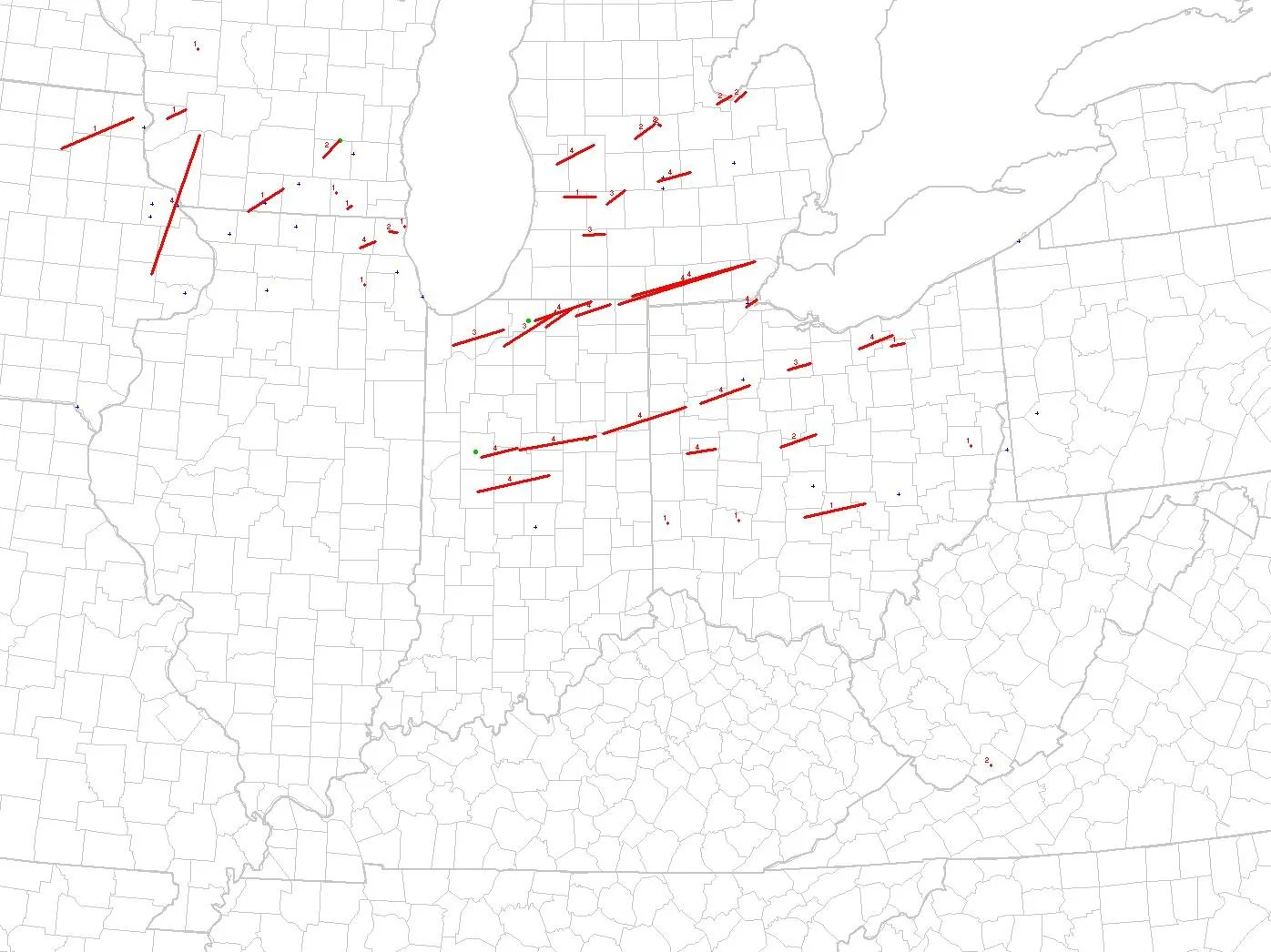
Palm Sunday 1965 tornado tracks. Courtesy: Dr. Russell Schneider, SPC
The Wind’s Wrath
In total 47 tornadoes touched down across the Midwest, but Indiana was the epicenter of devastation. In just a few hours, the state was ripped to shreds.
The Dunlap Nightmare: A violent tornado smashed the Midway Trailer Park in Dunlap, ripping homes from their frames and twirling them into the sky. Unthinkably, just over an hour later, a second violent tornado ripped through the exact same town, devastating subdivisions and a truck stop.
The Wells County F4: Even Ian’s home region wasn’t spared. A massive F4 tornado touched down west of Montpelier and tore through Keystone in Wells County, obliterating farms and leveling buildings before tearing into Adams County.
Russiaville and Kokomo: In Howard County, a mile-wide tornado damaged or destroyed 90 percent of structures in Russiaville before striking Alto and Kokomo.
The Grim Aftermath
After the sun rose on Monday, 137 Hoosiers were dead, and over 1,200 were injured. It remains the deadliest tornado outbreak in Indiana’s history. Entire families, church congregations, and neighborhoods were gone. The absolute scale of the tragedy finally forced the United States to overhaul its severe weather forecasting and warning systems, leading to the radar and alert networks we rely on today.
Unfortunately, for the families who sat down for Sunday dinner and never saw the following sunrise, those advancements came a bit too late.
References and Further Reading
1. National Weather Service (NWS) Northern Indiana. (n.d.). The Palm Sunday Outbreak of April 11, 1965. National Oceanic and Atmospheric Administration. Note: This is the primary meteorological source detailing the storm's 70 mph forward speed, the Dunlap "twin tornadoes," the Midway Trailer Park devastation, and the F4 track through Keystone and Wells County.
2. National Weather Service (NWS) Indianapolis. (n.d.). Palm Sunday Tornado Outbreak: April 11, 1965. National Oceanic and Atmospheric Administration. Note: This record provides the specific damage assessments for Central Indiana, including the mile-wide track and 90% structural destruction of Russiaville, as well as the impact on Alto and Kokomo.
3. Grazulis, T. P. (1993). Significant Tornadoes 1680–1991: A Chronology and Analysis of Events. The Tornado Project of Environmental Films. Note: The definitive historical archive used for classifying the historical F4 ratings, exact touchdown timelines, and the state-wide fatality count of 137.
4. Galway, J. G. (1989). The Evolution of Severe Thunderstorm Criteria within the Weather Service. Weather and Forecasting, 4(4), 585-592. Note: Documents the historical blind spots in the 1960s severe weather alerting capabilities and how the 1965 outbreak directly catalyzed the modernization of radar deployment and the national warning system.
5. Indiana Historical Bureau. (n.d.). Palm Sunday Tornadoes. State of Indiana. Note: Provides the cultural and historical context of the day, detailing the unseasonably warm morning conditions, the public's lack of preparedness, and the subsequent modernization of the state's emergency response networks.
